National alternative fuel network features autogas stations

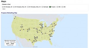
Click to view the Federal Highway Administration’s map of propane fueling stations in the United States. Photo courtesy of the Federal Highway Administration
The U.S. Department of Transportation’s Federal Highway Administration (FHWA) unveiled a map of national alternative fuel and vehicle charging stations across the United States, including for propane autogas.
According to FHWA, 55 routes serve as the basis for the national network of alternative fuel corridors, which spans 35 states. The network stretches about 85,000 miles, and the administration plans to add more miles to it to further accommodate electric, hydrogen, propane and natural gas vehicles.
According to FHWA’s maps, marked alternative fuel corridors with propane stations are located in Colorado, Connecticut, Illinois, Missouri, New York, Ohio, Pennsylvania, South Carolina, Texas, Utah, Virginia, Washington and Wisconsin.
FHWA designed alternative fuel station signs to place along the routes included in the network. According to the administration, corridors designated as “sign ready” – routes where alternative fuel stations are currently in operation – will be eligible to feature new signs alerting drivers where they can find fuel for alternative vehicles.
The designation of these corridors fulfills a directive included in the Fixing America’s Surface Transportation (FAST) Act. According to FHWA, Congress designated the specific fuels for the network in the FAST Act.
“Identifying where alternative fueling stations can be found will help the public in many ways,” says Federal Highway Administrator Gregory Nadeau. “This initial designation sets the stage for the next round of nominations early next year and begins a conversation with stakeholders about developing and implementing a vision to enable coast-to-coast travel using alternative fuels.”


